Mohamed Hachaichi

Ph.D. in circular urban metabolism & climate change, AI-driven enthusiast, and passionate about Ecological Transition.
Research papers
Assessing the ecological performance of French territories using a spatially-nested approach
Abstract
“Territories are at the forefront of efforts to curtail the trajectory of their environmental impacts and enhance their economic and ecological resilience. To expedite the process of curving the ecological footprint, France has launched the Ecological Transition Plan (ETP). However, environmental programs in France are orchestrated at the national and regional levels, which tends to diminish the heterogeneity of territorial dynamics. This underscores a disparity in scale that might potentially hinder the translation of the ETP’s objectives (Top-Down) into feasible local initiatives (Bottom-Up), and vice versa. To bridge this gap, we suggest employing the Ecological Footprint as a monitoring framework, in conjunction with a spatially-nested approach. This combination aims to guarantee the precise conversion of objectives into impactful local actions. Results reveal that only 27% of French territories are encountering an ecological deficit, while the remaining 73% are classified as ecological reserves. The primary sectors contributing to this ecological overshoot are “road transport” (28.8%), followed by “industry” (21.4%), and “agriculture” (19.5%). We posit that this spatially-nested analysis can unravel territorial heterogeneities and facilitate the design of more nuanced and appropriately tailored ecological actions across different scales.”

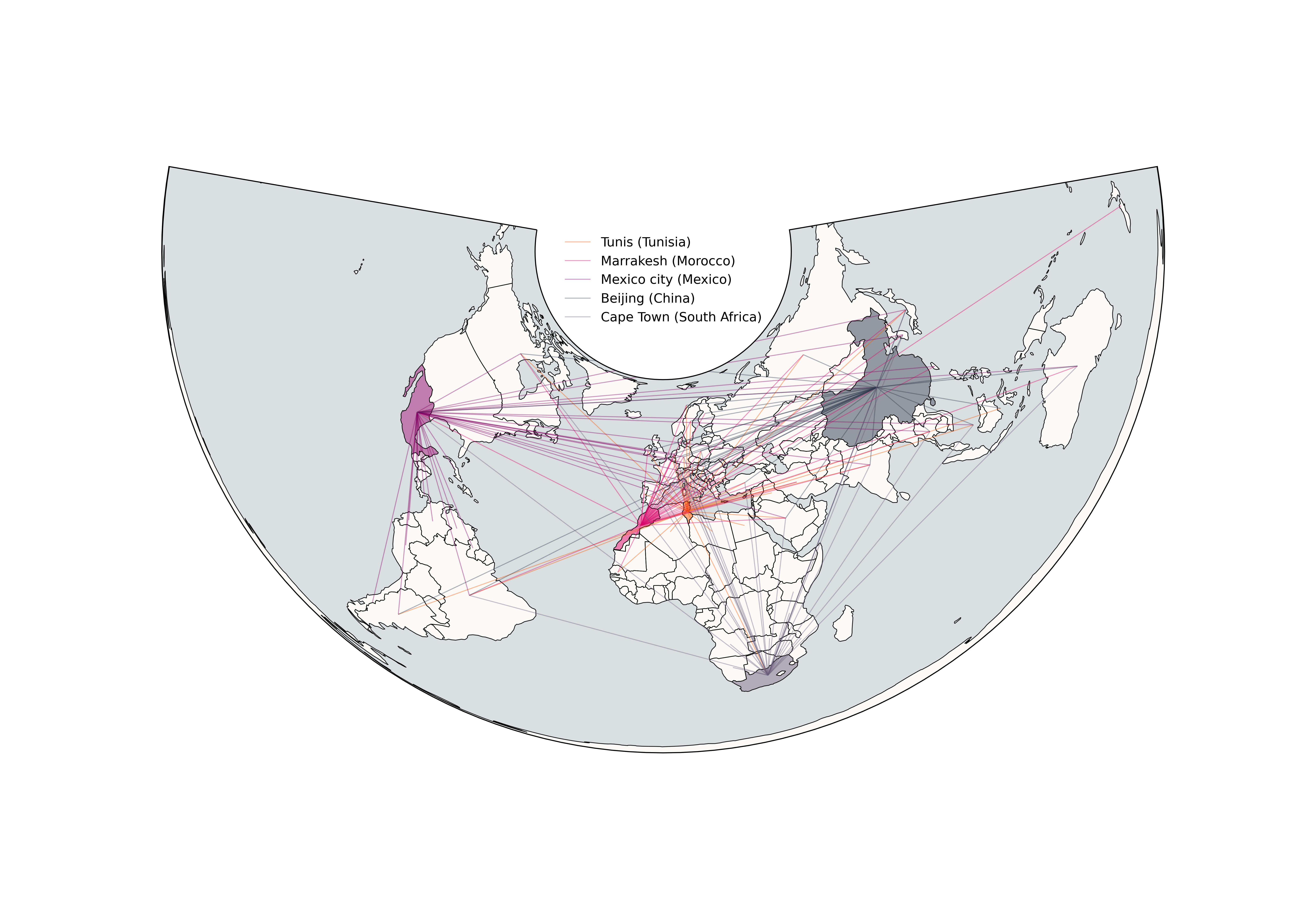
No City Left Behind: Building Climate Policy Bridges between the North and South
Abstract
“Cities are progressively heightening their climate aspirations to curtail urban carbon emissions and establish a future where economies and communities can flourish within the Earth’s ecological limits. Consequently, numerous climate initiatives are being launched to control urban carbon emissions, targeting various sectors, including transport, residential, agricultural, and energy. However, recent scientific literature underscores the disproportionate distribution of climate policies. While cities in the Global North have witnessed several initiatives to combat climate change, cities in the Global South remain uncovered and highly vulnerable to climate hazards. To address this disparity, we employed the Balanced Iterative Reducing and Clustering using the Hierarchies (BRICH) algorithm to cluster cities from diverse geographical areas that exhibit comparable socioeconomic profiles. This clustering strives to foster enhanced cooperation and collaboration among cities globally, with the goal of addressing climate change in a comprehensive manner. In summary, we identified similarities, patterns, and clusters among peer cities, enabling mutual and generalizable learning among worldwide peer-cities regarding urban climate policy exchange. This exchange occurs through three approaches: (i) inner-mutual learning, (ii) cross-mutual learning, and (iii) outer-mutual learning. Our findings mark a pivotal stride towards attaining worldwide climate objectives through a shared responsibility approach. Furthermore, they provide preliminary insights into the implementation of “urban climate policy exchange” among peer cities on a global scale.”

Unpacking the urban virtual water of the Global South: Lessons from 181 cities
Abstract
“Most of the water humanity currently consumes is invisible, it is embedded within goods and services purchased by final consumers from the global economic market. Cities of the Global South (GS) – especially African and Asian cities are facing twofold water security problems. First, the increased risk of water availability (both quantity and quality), which is exacerbated by climate change. Second, the ever-increasing water demand due to their economic and population growth. Therefore, to help cities of the GS to efficiently manage their water resources, it is crucial to explore what products are being imported from the global economic market and assess their embodied water intensities. Herein, the water footprints (blue and grey) of 181 cities from the GS are computed using Extended Environmental Input-Output Analysis (EE-IOA). Results point out that water imports through virtual water are significant and growing even across the GS with different magnitudes because of the economic attributes of cities (expenditures patterns) and their geography (spatial location). The average blue virtual water is estimated to be 253 l per capita/yr and 285 l per capita/yr for virtual grey water. When decomposing the water footprint we found that the major responsible sectors are “Food” accounting for 37% of the total footprint, followed by “Transport” with 24%, and “Energy” with 22%. To put the climate impacts in perspective, cities of the GS must act in a proactive approach and use the water-trade nexus as a supplementary approach to shape and implement water security strategies.”
Wheels within wheels: Mapping the genealogy of circular economy using Machine Learning
Abstract
“The literature on circular economy (CE) is growing significantly. Although the concept emerged in the 1970s, it is only very recently that it has gained interest in the scientific community. However, little is known about its genealogy, how the international community was formed, and how concepts were approached and developed by mobilizing different theoretical approaches, especially in humanities and social sciences. This study fills this gap by shedding light on the recent developments in the field from a regional perspective. We used computer-assisted methods (natural language processing, topic modeling, geoparsing, scientometrics, and computational linguistics) on textual data to capture the field’s framework evolution, highlight main topics, identify key drivers, map the geography of knowledge production, and scrutinize the numerous types of the spatial proximities waved between its actors. To our knowledge, this is the first attempt to trace the geographic genealogy of CE using large-scale textual data to produce in-depth knowledge regarding the spatiotemporal genesis of the field by unpacking how closed-loop systems are analyzed across regions, worldwide.”

Small modular reactors: An assessment of workforce requirements and operating costs
Abstract
“In the past seven years, global warming discourse has revolved around restricting temperature increases to under 2 °C above pre-industrial levels by utilizing such low-carbon energy sources as nuclear, solar, and wind energy. However, the use of nuclear energy for electricity generation via conventional nuclear power plants (NPPs) has met stiff challenges due to high capital costs, thereby constraining newcomer nations. A solution contending high capital costs for NPPs is the introduction of small modular reactors (SMRs) that has garnered attention over the past ten years because of their lower initial capital investment, scalability, and ease of deployment for less developed electricity grid and small areas of low electricity demand. In this study, the workforce requirements and salaries component for operating workers of 300 MWe integral Pressurized Water Reactors (iPWR) SMR is modeled and assessed using an upgraded International Atomic Energy Agency (IAEA) Nuclear Power Human Resources (NPHR) modeling tool from 2018 to 2055. The results show that at a discount rate of 10% an average annual salary payment, the net present cost (NPC) for the operating workers is approximately 431 million USD with a standard deviation of 8%. Moreover, the results further show that at the end of themodeling period and considering 43 function areas in a typical NPP, the top three functions to be recruited and contributing to the total domestic workers for a typical newcomer nuclear nation are Maintenance/Construction (18.17%), Operations (9.02%), and Management (8.22%) workers. The results enable the estimation of human resource requirements to operate an SMR over its life cycle, which in turn enables informed budgeting for human resources.”

Territorial impacts of COVID-19 and policy answers in European regions and cities
Abstract
“What does the geographical pattern of the Covid-19 pandemic look like across European regions and cities and how has it evolved since the beginning of the pandemic? Are there specific territorial and/or socio-economic characteristics that can entail a higher risk of death/more severe course of disease and/or higher probabilities of negative socio-economic impacts? Which factors explain best the level of exposure of cities, regions and functional urban areas to the Covid-19 pandemic? How can different exposure levels in different types of territories be explained? To which degree have poverty, social inequalities and social exclusion been affected by the pandemic and subsequent lockdown measures? Can local wealth conditions, poverty or inequalities explain why territories are more or less affected by the virus diffusion? Which ‘proactive’ policy approaches to coping with the pandemic during and after the first wave have proved to be working well for European regions and cities? Has it been possible to use “windows of opportunities” opened by the pandemic? How important has multi-level and cross-sectoral governance been in responding to the pandemic? Have decisions taken by local authorities had an impact beyond their administrative borders? How has the pandemic affected cooperation at the metropolitan/functional regional level? How can territorial cooperation frameworks, tools and resources for cross–border regions be strengthened in times of crises? This final report is conducted within the framework of the ESPON 2020 Cooperation Programme, partly financed by the European Regional Development Fund. The ESPON EGTC is the single beneficiary of the ESPON 2020 Cooperation Programme. The single operation within the programme is implemented by the ESPON EGTC and co-financed by the European Regional Development Fund, the EU Member States and the Partner States, Iceland, Liechtenstein, Norway and Switzerland. This delivery does not necessarily reflect the opinions of members of the ESPON 2020 Monitoring Committee.”

Abstract
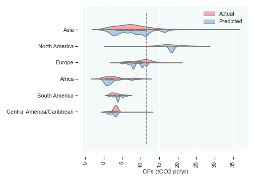
“Computing global cities’ carbon footprints is core in allocating regional climate change responsibilities and cutting urban carbon emissions. However, cities’ carbon footprint of the Global North are better documented than those in the Global South. Although cities belonging to developing countries, especially African and Asian cities, are growing significantly in terms of size, population, GDP, their carbon footprint remains poorly documented in the scientific literature. Cities’ carbon footprints inventories of the Global South are usually hampered by (i) lack of local urban emissions data, (ii) reduced climate footprint, and (iii) shortages in climate finance. To bridge this gap, we aim to estimate 24,110 cities’ carbon footprints using machine learning algorithms to provide a comprehensive analysis on a planetary scale, while allocating responsibilities according to the cities’ regions and sizes. The findings highlight that such a granular approach can enhance future global climate collaboration by erupting a robust local, and thus global, climate-friendly actions and increase peer-cities climate readiness.”
Abstract
“Since the Industrial Revolution and with the rapid changes of production-consumption paradigms, cities have become a hot-spot for materials and energy consumption. Urban anthropogenic activities have given birth to many multi-scalar environmental distortions such as: global warming, biodiversity loss, waste disposal, and many other inter-linked environmental damages. Unfortunately, Earth’s life-support system is compromising each year and it is unable to sustain the upcoming population growth and its divergent needs, as such, bringing the world’s economy with the global environmental thresholds is irrefutable to maintain human civilization in our solar system. This study tends to exhibit that, within our current environmental uncertainties, contemporary cities-within the digital age-must reshape their urban model in concordance with the Planetary Boundaries’ 1 (PBs) framework. Our goal is to show that MIC’s urban ecosystems are not in a dynamic nor in a static equilibrium likewise they are too vulnerable to the new extreme climate events. Redesigning cities’ urban model using environmental thresholds “biocapacity” is thus highly relevant to upgrade the coping capacity of urban ecosystems. Notice that the current article does not aim to explain the divergent trans-disciplinary meanings of resiliency nor the dilemma of whether to include or exclude the carbon footprint component from the ecological footprint indicator. Not surprisingly, we highly believe that “resiliency” could be a new urban utopia, the vague promise of a radiant horizon for humankind survival from the terrifying perspective of the Anthropocene.”

Abstract
“Understanding how water, food, and energy interact in the form of the water-food-energy (WFE) nexus is essential for sustainable development which advocates enhancing human well-being and poverty reduction. Moreover, the application of the WFE nexus has seen diverse approaches to its implementation in cities across the globe. There is a need to optimize knowledge sharing to improve urban information exchange focused on the WFE nexus’ application and impact on the UN Sustainable Development Goals. In this study, Natural language processing (NLP) and affinity propagation algorithm are employed to explore and assess the application of the WFE nexus on a regional basis as well as at city levels. The results show that after the exhaustive search of a database containing 32,736 case studies focusing on 2,233 cities, cities with the most potential to encounter resource shortages (i.e. WFE limitation) are systematically underrepresented in literature (African and Latin American cities). Hence, with regional and topic bias, there is a potential for more mutual learning links between cities that can increase WFE nexus policy exchange between Northern and Southern hemispheres through bottom-up case-study knowledge. In addition, this study shows that Southern hemisphere cities can benefit from knowledge transfer because of their limited urban intelligence programs.”

Abstract
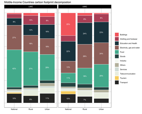
“The Paris agreement nominates cities as a core element to set climate mitigation actions so humanity does not exceed the global climate budget fixed at 1170 (Gt) and eventually remains on track with the 2 °C guard rail. Current carbon footprint literature provides a deep analysis of cities belonging to high-income countries, but it is extremely limited when it comes to cities belonging to middle-income and low-income countries regardless of their global significance. This research bridges this gap through the computation of the carbon footprints of 252 cities located in middle-income countries. Results show that the average carbon footprint across all the urban areas of upper middle-income countries is estimated to 5.31 t CO2 and 3.41 t CO2 in the rural areas. Our research highlights that embodied carbon emissions are important in developing cities as in developed cities and that local authorities must take into account upstream emissions at city scale to move forward their second-generation environmental challenges within their climate-friendly portfolio.”
Abstract
“Modern cities are considered as the most harmful artifacts created by mankind since 5400 BCE within the Sumerian civilization (Eridu). Since then, cities have continued to proliferate and expand across the world accompanying homo sapiens revolutions and becoming the origin of many environmental disruptions. Indeed, modern societies’ behaviors and lifestyle patterns are pushing the urban system dynamics to be more complex and more dependent on the global economic market. Likewise, redesigning modern cities and industrialized societies to cope up with the contemporary environmental challenges is inevitable for maintaining Earth’s life-support system. Our study provides the first glimpse estimations of different footprints (CO2; Harvested primary corps; Raw Material Inputs; Nitrogen; Phosphorus; Cropland pasture land and Freshwater) for big cities in the MENA region broken down into five major consumption categories using an Extended-Environmental Input-Output (EE-IO) analysis which shed light on the relation between urban economic consumption and associated environmental impacts. Down-scaling the planetary boundaries indicators (Pbs) to city scale level can be used to reinforce the operational scope of existing urban sustainability agendas or in designing new urban tools to better orchestrating growing economies into the global environment sustainability issues. To our knowledge, this study is the first on downscaling the Pbs framework to city scale level and providing first footprints insights on a part of the world that is not enough scientifically explored.”

Abstract
“The current study sets to determine theoretical paths in order to balance Algiers CO2 emissions with city’s carbon sink capacity by i) calculating carbon sink potential (forest land, wetlands, soil and technology) and ii) calculating Algiers’ carbon emissions considering territorial emissions (Scope 1 and 2) within Algiers’ administrative boundaries. The analysis shows that Algiers carbon emissions (estimated to 392 9243 t CO2) exceed the city carbon sink capacity (estimated to 157 4044 t CO2) by 1.5 times. Thus, per capita carbon emissions in Algiers for the year of 2016 were estimated to 1.24 tones CO2/y composed by 0.84 tones CO2/y (67.7%) from the combustion of fossil-fuels and 0.39 tones CO2 (31.4%) from the consumption of electricity. This study exhibits that in order to live within Algiers’ carbon budget, urban policy-makers should endeavor three major paths to accommodate Algiers carbon deficit: either i) to limit Algiers’s population to 1 268 963 inhabitants-that means 1/3 of Algiers’ current population size-. ii) increase Algiers’s ecological assets area to 36 709 ha. or iii) introduce and generalize decarbonized energy for residential and transportation sectors which represent the main driving sectors for CO2 emissions as they emit respectively 25% and 51% of Algiers total CO2 emissions. City-level carbon emissions inventory can help to introduce cities with developing economies, such as Algiers, into the global climate issues and suggest solid recommendations for shifting current urban models towards a more sustainable urban planning intricately linked to sustainable forest management.”

Abstract
“Environmental sustainability rather than a trans-disciplinary and a scientific issue, is the main problem that characterizes all modern cities nowadays. In developing countries, this concern is expressed in a plethora of critical urban ills: traffic congestion, air pollution, noise, urban decay, increase in energy consumption and CO 2 emissions which blemish cities’ landscape and might threaten citizens’ health and welfare. As in the same manner as developing world cities, the rapid growth of Algiers’ human population and increasing in city scale phenomena lead eventually to increase in daily trips, energy consumption and CO 2 emissions. In addition, the lack of proper and sustainable planning of the city’s infrastructure is one of the most relevant issues from which Algiers suffers. The aim of this contribution is to estimate the carbon deficit of the City of Algiers, Algeria, using the Ecological Footprint Model (carbon footprint). In order to achieve this goal, the amount of CO 2 from fuel combustion has been calculated and aggregated into five sectors (agriculture, industry, residential, tertiary and transportation); as well, Algiers’ biocapacity (CO 2 uptake land) has been calculated to determine the ecological overshoot. This study shows that Algiers’ transport system is not sustainable and is generating more than 50% of Algiers total carbon footprint which cannot be sequestered by the local forest land. The aim of this research is to show that the Carbon Footprint Assessment might be a relevant indicator to design sustainable strategies/policies striving to reduce CO 2 by setting in motion the energy consumption in the transportation sector and reducing the use of fossil fuels as the main energy input.”
